<?xml version="1.0" encoding="utf-8"?>
<feed xmlns="http://www.w3.org/2005/Atom" xmlns:media="http://search.yahoo.com/mrss/">
    <title>Snaprails Snippets</title>
    <link href="https://snaprails.org.uk/feed.xml" rel="self" />
    <link href="https://snaprails.org.uk" />
    <updated>2026-11-21T12:56:27+00:00</updated>
    <author>
        <name>Don Constance</name>
    </author>
    <id>https://snaprails.org.uk</id>

    <entry>
        <title>Richmond Draw-Off</title>
        <author>
            <name>Don Constance</name>
        </author>
        <link href="https://snaprails.org.uk/richmond-draw-off/"/>
        <id>https://snaprails.org.uk/richmond-draw-off/</id>
            <category term="Walking"/>
            <category term="River Thames"/>
            <category term="Richmond"/>
            <category term="London"/>

        <updated>2026-11-21T12:56:27+00:00</updated>
            <summary type="html">
                <![CDATA[
                    Each year in order to carry out essential maintenance works on Richmond&hellip;
                ]]>
            </summary>
        <content type="html">
            <![CDATA[
                <p>Each year in order to carry out essential maintenance works on Richmond lock, weirs and sluices, the Port of London Authority hold up the weirs across the low tide period, at Richmond Lock and Weir. Normally enough water is let through to maintain a nominal level of 1.72m above Ordnance Datum Newlyn, but during the Draw-Off with the weir sluices closed the bed of the river becomes exposed. Bad news for boaters who either need to move their vessels or ensure that they can safely "take the ground" when there's no water to float them. A good excuse for a walk along the river bank with a camera to capture an unusual view of the Thames though.</p>
<p><a href="https://pla.co.uk/notices/U35-26" title="PLA website draw-off notice" target="_blank" rel="nofollow noopener noreferrer">The 2026 Draw-Off</a> commenced on November 5th and continues until December 18th. I went along on November 16th having carefully checked the <a href="https://pla.co.uk/tidal-information" title="PLA website tidal info" target="_blank" rel="nofollow noopener noreferrer">tide times</a> to make sure low water would be at a convenient time of day and not in the middle of the night. I caught the train to Richmond, grabbed a coffee, and wandered down across Richmond Green and along Old Palace Lane to the riverside where I found that there was rather more water than I expected. I walked along to Richmond Lock &amp; Weir and confirmed that it was indeed closed, as was the footbridge over the top.</p>
<p><a data-flickr-embed="true" href="https://www.flickr.com/photos/snaprails/55656139347/in/album-72177720337084534/" title="Richmond Draw-off, River Thames, Richmond Lock &amp; Weir"><img loading="lazy" src="https://live.staticflickr.com/65535/55656139347_c0d2660cdf.jpg" alt="Richmond Draw-off, River Thames, Richmond Lock &amp; Weir" width="500" height="376" data-is-external-image="true"></a>
<script async="" src="//embedr.flickr.com/assets/client-code.js" charset="utf-8"></script>
</p>
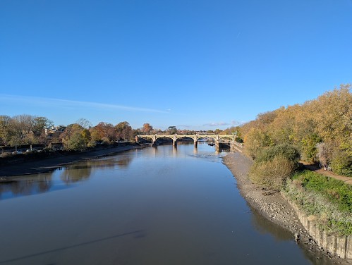
<p>With the weir footbridge closed I returned to Twickenham Bridge in order to cross to the North bank of the river. From the bridge there was more evidence that there was a lack of water, with a few boats aground by Corporation Island and under the railway bridge. I decided to stay on the North bank and carry on along Horse Reach towards Twickenham. Once around the bend and opposite Petersham Meadows the lack of water became much more obvious.</p>
<p><a data-flickr-embed="true" href="https://www.flickr.com/photos/snaprails/55657256443/in/album-72177720337084534/" title="Richmond Draw-off, River Thames, Horse Reach &amp; Petersham Meadows"><img loading="lazy" src="https://live.staticflickr.com/65535/55657256443_8478038e88.jpg" alt="Richmond Draw-off, River Thames, Horse Reach &amp; Petersham Meadows" width="500" height="376" data-is-external-image="true"></a>
<script async="" src="//embedr.flickr.com/assets/client-code.js" charset="utf-8"></script>
</p>
<p>As you can see it was a glorious day for a walk by the river. Or if you were a metal detectorist with good wellies a walk <em>in</em> the river like this chap near Marble Hill House. I'm going to assume he has a PLA Mudlarking Licence in which case Mrs. old-busybody-in-yellow-trousers on the towpath, it <em>is</em> legal. Not that it's really any of your concern.</p>
<p><a data-flickr-embed="true" href="https://www.flickr.com/photos/snaprails/55657259548/in/album-72177720337084534/" title="Richmond Draw-off, River Thames, mudlarking near Marble Hill Park"><img loading="lazy" src="https://live.staticflickr.com/65535/55657259548_3f5d1952e4.jpg" alt="Richmond Draw-off, River Thames, mudlarking near Marble Hill Park" width="500" height="375" data-is-external-image="true"></a>
<script async="" src="//embedr.flickr.com/assets/client-code.js" charset="utf-8"></script>
</p>
<p>The motor cruisers moored at the pier by Hammerton's Ferry were definitely going nowhere any time soon, ironically one of which appeared to be balanced precariously on its keel and was named "High Level".  I continued past the ferry (closed for the winter) and took a detour to Orleans House Gallery. Not for any artistic reasons but because although sunny it was still quite cold and that coffee I'd had in Richmond wanted out.</p>
<p><a data-flickr-embed="true" href="https://www.flickr.com/photos/snaprails/55656142047/in/album-72177720337084534/" title="Richmond Draw-off, River Thames, grounded boats, Hammerton's Ferry jetty"><img loading="lazy" src="https://live.staticflickr.com/65535/55656142047_66f4b62e44.jpg" alt="Richmond Draw-off, River Thames, grounded boats, Hammerton's Ferry jetty" width="500" height="375" data-is-external-image="true"></a>
<script async="" src="//embedr.flickr.com/assets/client-code.js" charset="utf-8"></script>
</p>
<p>Back along the riverside I passed the slipway near The White Swan pub where from the 17th century until around 1970 the Twickenham Ferry, also known as Dysart's Ferry crossed the river to Ham House, which was owned by the Dysart family. <a href="https://www.nationaltrust.org.uk/visit/london/ham-house-and-garden" title="NT website Ham House &amp; Gardens" target="_blank" rel="nofollow noopener noreferrer">Ham House &amp; Gardens</a> is now owned by the National Trust and well worth a visit.</p>
<p>A little further along the road (Riverside) I came to Champions Wharf in front of St. Mary the Virgin church. Opposite lay Eel Pie Island with it's busy boatyard and all the boats firmly aground.</p>
<p><a data-flickr-embed="true" href="https://www.flickr.com/photos/snaprails/55657123691/in/album-72177720337084534/" title="Richmond Draw-off, River Thames, Eel Pie Boatyard"><img loading="lazy" src="https://live.staticflickr.com/65535/55657123691_7600f2eaf9.jpg" alt="Richmond Draw-off, River Thames, Eel Pie Boatyard" width="500" height="375" data-is-external-image="true"></a>
<script async="" src="//embedr.flickr.com/assets/client-code.js" charset="utf-8"></script>
</p>
<p>Standing on the slipway beside the wharf I wished I'd had my Wellies for I could easily have walked across to <a href="https://en.wikipedia.org/wiki/Eel_Pie_Island" title="Wikipedia, Eel Pie Island entry" target="_blank" rel="nofollow noopener noreferrer">Eel Pie Island</a>. Having only walking shoes though I decided that discretion would be preferable to sitting on my arse in the slippery Thames mud. Instead I climbed up onto the high arched footbridge, following in the footsteps of George Melly, Acker Bilk, The Rolling Stones, Pink Floyd, Black Sabbath, and many more famous musical acts. Well metaphorically anyway since the current bridge dates only from 1998, the first one built in 1957 having been damaged beyond repair by a utilities contractor. I was though following in the footsteps of wind-up radio inventor Trevor Baylis who lived on the island until his death in 2018.</p>
<p><a data-flickr-embed="true" href="https://www.flickr.com/photos/snaprails/55657326414/in/album-72177720337084534/" title="Richmond Draw-off, River Thames, from Eel Pie Island, Twickenham"><img loading="lazy" src="https://live.staticflickr.com/65535/55657326414_c5c9a0cb13.jpg" alt="Richmond Draw-off, River Thames, from Eel Pie Island, Twickenham" width="500" height="376" data-is-external-image="true"></a>
<script async="" src="//embedr.flickr.com/assets/client-code.js" charset="utf-8"></script>
</p>
<p>I didn't stray far beyond the big sign stating "PRIVATE ISLAND NO THOROUGHFARE OR ACCESS TO THE RIVER NO CYCLING" but returned to the North bank. Progress along The Embankment being impeded by building works I walked up Water Lane into Twickenham town centre, turned left, then bore left again down Cross Deep passing Kneller Hall School to regain the riverbank in Radnor Gardens. My last look at the river was at Swan Island in Strawberry Hill where the boats rested on thick mud.</p>
<p><a data-flickr-embed="true" href="https://www.flickr.com/photos/snaprails/55657263913/in/album-72177720337084534/" title="Richmond Draw-off, River Thames, Swan Island, Strawberry Hill"><img loading="lazy" src="https://live.staticflickr.com/65535/55657263913_087de150a2.jpg" alt="Richmond Draw-off, River Thames, Swan Island, Strawberry Hill" width="500" height="375" data-is-external-image="true"></a>
<script async="" src="//embedr.flickr.com/assets/client-code.js" charset="utf-8"></script>
</p>
<p>The afternoon was wearing on so I headed back to Richmond on the R68 bus and after coffee and pastry caught the rather crowded train towards home. It had indeed been a nice day for a walk along the Thames.</p>
<p>I seem to have taken quite a lot of photos - I even risked taking a proper camera for a change instead of just a smartphone. <a href="https://flic.kr/s/aHBqjDcp7o" title="Flickr: Along the Thames at the Richmond Draw-off" target="_blank" rel="noopener noreferrer">You can see them in this Flickr Album.</a> Or in the slideshow below if your viewing device supports it.</p>
<p> <a data-flickr-embed="true" href="https://www.flickr.com/photos/snaprails/albums/72177720337084534" title="Along the Thames at the Richmond Draw-off"><img loading="lazy" src="https://live.staticflickr.com/65535/55656145777_139cd4644c.jpg" alt="Along the Thames at the Richmond Draw-off" width="500" height="375" data-is-external-image="true"></a>
<script async="" src="//embedr.flickr.com/assets/client-code.js" charset="utf-8"></script>
</p>
<p> </p>
            ]]>
        </content>
    </entry>
    <entry>
        <title>A walk along the mildmay Line</title>
        <author>
            <name>Don Constance</name>
        </author>
        <link href="https://snaprails.org.uk/a-walk-along-the-mildmay-line/"/>
        <id>https://snaprails.org.uk/a-walk-along-the-mildmay-line/</id>
            <category term="Walking"/>
            <category term="Travel"/>
            <category term="Railways"/>
            <category term="London"/>

        <updated>2026-11-20T16:19:01+00:00</updated>
            <summary type="html">
                <![CDATA[
                    My little urban walking project in September and October was to walk&hellip;
                ]]>
            </summary>
        <content type="html">
            <![CDATA[
                <p>My little urban walking project in September and October was to walk across London avoiding the most touristy bits and to create a guide to the route.</p>
<p>I wanted a walk that could be divided into easy stages and those stages needed to be easily accessible by public transport.</p>
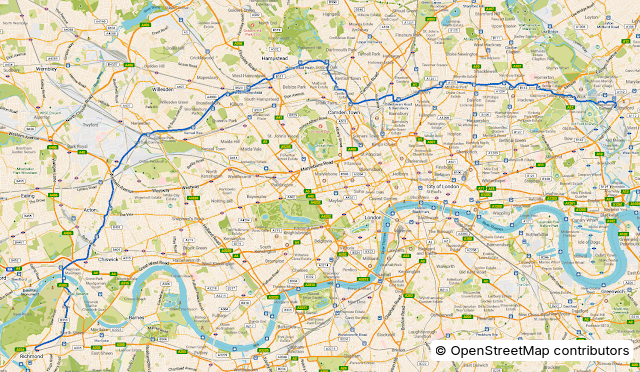
<p>Inspired by the great author and film maker John Rogers walk from Leyton to Gospel Oak along the Suffragette Line of the <a href="https://youtu.be/dcYa6VBotRs" target="_blank" rel="nofollow noopener noreferrer">London Overground</a> I looked to see if any of the other Overground lines might provide a suitable route. The Mildmay Line, or the part of it which was mostly the former North London Railway looked promising. From Richmond in the Southwest to Stratford in the East via all the intermediate stations is about 22.5 miles (36km) and fitted the other requirements as well. It passed through enough different districts of London that there was likely to be something of interest to see along the way.</p>
<figure class="post__image post__image--center"><img loading="lazy"  src="https://snaprails.org.uk/media/posts/7/full_route_overview.png" alt="" width="640" height="372" sizes="(min-width: 760px) 660px, calc(93.18vw - 30px)" srcset="https://snaprails.org.uk/media/posts/7/responsive/full_route_overview-xs.webp 320w ,https://snaprails.org.uk/media/posts/7/responsive/full_route_overview-sm.webp 480w ,https://snaprails.org.uk/media/posts/7/responsive/full_route_overview-md.webp 768w ,https://snaprails.org.uk/media/posts/7/responsive/full_route_overview-xl.webp 1024w"></figure>
<p>I started off by plotting the route in four sections using Ordnance Survey online mapping - got to get something out of my annual subscription - and then exporting the GPS files to use in CoMaps on my phone and desktop. Next I viewed the proposed route on OpenStreetmaps and in Google Streetview to produce a set of walking directions. For most of the route this wasn't too hard but approaching Stratford the maps and Streetview imaging are a bit out of date so it was a case of best guess and confirm later on the ground.</p>
<p>Once I had some plans it was time to grab a clipboard and pen and hit the streets to make sure they made sense and to tweak and add information where needed. I started at Richmond and walked to Acton Central. The next outing I walked Acton Central to West Hampstead, the time after that was West Hampstead to Caledonian Road and Barnesbury, and the final trip was Caledonian Road and Barnesbury to Stratford. I was surprised how little I needed to amend the original directions, even at Stratford. Although I was walking the streets with a clipboard and pen and taking photos (which gave me a sense of deja vu 😀 ) only once did anyone ask me what I was doing and he was very, very drunk and I suspect had some mental health issues. Mind you if <em>I</em> see anyone in the street with a clipboard I try to avoid them in case they're doing some sort of marketing survey and want to ask me lots of questions. I kept an eye out for blue plaques and other bits and bobs in the street and added notes about them to my piece of paper to look up later. I learnt new things, which is partly the point of the walk.</p>
<p>Back home after each trip I wrote up and amended the directions, adding annotated maps to add clarity where necessary. (<a href="https://gradia.alexandervanhee.be/" title="Link to Gradia website" target="_blank" rel="nofollow noopener noreferrer">Gradia is a useful tool for that sort of thing.</a>) I also tweaked the GPS routes to avoid a couple of places where I decided there was a safer route to walk. </p>
<p>After a number of revisions I was finally happy that I could let it out into the wild so London now has yet another walking route. If you want to walk it or just look at the guide out of interest you can download it free from the Internet Archive here:</p>
<p><a href="https://archive.org/details/the-mildmay-line-walk-a-guide" title="link to archive.org" target="_blank" rel="nofollow noopener noreferrer">https://archive.org/details/the-mildmay-line-walk-a-guide</a></p>
<p>Happy wandering.</p>
<p>Would I do this again? Quite possibly. There's another branch of the Mildmay Line from Clapham Junction to Willesden...</p>
            ]]>
        </content>
    </entry>
    <entry>
        <title>Website change</title>
        <author>
            <name>Don Constance</name>
        </author>
        <link href="https://snaprails.org.uk/website-change/"/>
        <id>https://snaprails.org.uk/website-change/</id>
            <category term="Website"/>

        <updated>2026-11-20T15:11:52+00:00</updated>
            <summary type="html">
                <![CDATA[
                    This is a test post. It's time for a change to my&hellip;
                ]]>
            </summary>
        <content type="html">
            <![CDATA[
                <p><strong>This is a test post.</strong></p>
<p>It's time for a change to my website. The new site is being created using <a href="https://getpublii.com/" title="Publii Website" target="_blank" rel="nofollow noopener noreferrer">Publii</a> and should allow easier updates and an integrated blog.</p>
<p>Watch this space.</p>
<figure class="post__image post__image--center"><img loading="lazy"  src="https://snaprails.org.uk/media/posts/6/donphoto.png" alt="Profile picture" width="100" height="125" sizes="(min-width: 760px) 660px, calc(93.18vw - 30px)" srcset="https://snaprails.org.uk/media/posts/6/responsive/donphoto-xs.webp 320w ,https://snaprails.org.uk/media/posts/6/responsive/donphoto-sm.webp 480w ,https://snaprails.org.uk/media/posts/6/responsive/donphoto-md.webp 768w ,https://snaprails.org.uk/media/posts/6/responsive/donphoto-xl.webp 1024w"></figure>
            ]]>
        </content>
    </entry>
</feed>